NewTopo (NZ) Ltd
  • Home
  • Maps
    • North Island Maps
      • Cape Reinga map
      • Bay of Islands map
      • Aotea Great Barrier Island map
      • Auckland wall map
      • Coromandel Peninsula map
      • Waikaremoana map
      • Rotorua Taupō map
      • Tongariro Alpine Crossing map
      • Tongariro Northern Circuit map
      • Ruapehu Round the Mountain Track map
      • Mount Ruapehu map
      • Taranaki Mt Egmont map
      • Tararua Tramps map
      • Wellington map
      • Wellington wall map
    • South Island Maps
      • Marlborough Sounds Map
      • Queen Charlotte Track map
      • Kahurangi map
      • Abel Tasman map
      • Golden Bay map
      • Mt Arthur, Cobb Valley map
      • Heaphy Track map
      • Wangapeka Track map
      • Old Ghost Road map
      • Paparoa Track map
      • Travers-Sabine Circuit map
      • St James Walkway map
      • Lake Sumner Tramps map
      • Arthur's Pass map
      • Banks Peninsula map
      • Aoraki Mt Cook map
      • Wilkin Valley map
      • Central Otago map
      • Rees-Dart Track map
      • Five Passes Wilderness map
      • Routeburn, Greenstone map
      • Milford Track map
      • Kepler Track map
      • Hump Ridge Track map
      • Rakiura Track map
      • Rakiura Circuits map
      • Rakiura Stewart Island
  • Where To Buy
    • Europe / Rest of World
  • Free Downloads
  • Links
  • NZTM Grid
  • About NewTopo
    • Contact NewTopo
    • Terms and Conditions
Maps  >  North Island Maps  >  Wellington Outdoors map

Wellington Outdoors

Picture
Picture
Edition 2  2020.  Scale 1:55 000
A1 format, double sided. Skew orientation.
​Printed on waterproof synthetic paper.
Delivery Destination
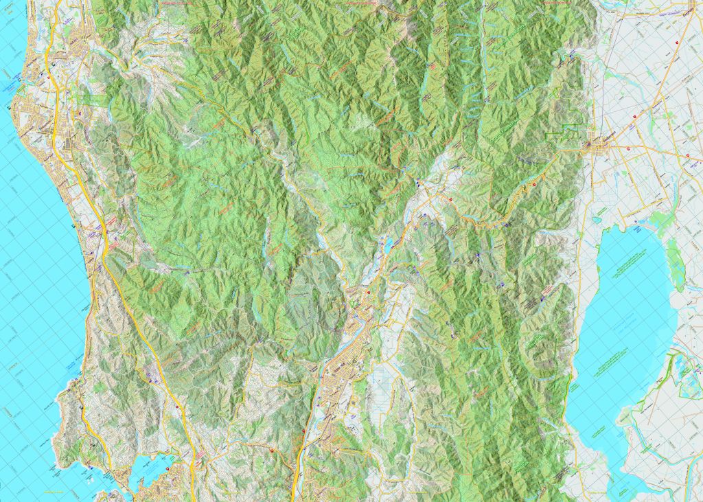
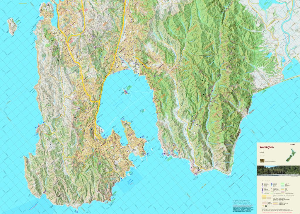
Wellington is surrounded by outdoor opportunities that present both challenges and enjoyment.  This new map shows these activities, the walking tracks, and the access roads to them.  
The combination of contours and relief shading, gives a realistic landform.  The map overlaps the Tararua Tramps map map to the North.
Error: On the northern edge of the map the distance from the Akatarawa Saddle to Renata Hut should read four hours and to the Waiotauru Hut should read five hours.
Picture

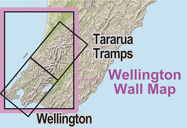
Overseas?
Stanfords in the UK also sell a selection of NewTopo Maps online.
​In Australia try the Chart and Map Shop in Fremantle, WA, or the Geographica map centre in Hobart, Tasmania.
Picture
Please read our terms & conditions, including delivery and return information.
​​Orders are normally despatched within 24 hours.  NZPost delivery can take 7-10 days.
Powered by Create your own unique website with customizable templates.
  • Home
  • Maps
    • North Island Maps
      • Cape Reinga map
      • Bay of Islands map
      • Aotea Great Barrier Island map
      • Auckland wall map
      • Coromandel Peninsula map
      • Waikaremoana map
      • Rotorua Taupō map
      • Tongariro Alpine Crossing map
      • Tongariro Northern Circuit map
      • Ruapehu Round the Mountain Track map
      • Mount Ruapehu map
      • Taranaki Mt Egmont map
      • Tararua Tramps map
      • Wellington map
      • Wellington wall map
    • South Island Maps
      • Marlborough Sounds Map
      • Queen Charlotte Track map
      • Kahurangi map
      • Abel Tasman map
      • Golden Bay map
      • Mt Arthur, Cobb Valley map
      • Heaphy Track map
      • Wangapeka Track map
      • Old Ghost Road map
      • Paparoa Track map
      • Travers-Sabine Circuit map
      • St James Walkway map
      • Lake Sumner Tramps map
      • Arthur's Pass map
      • Banks Peninsula map
      • Aoraki Mt Cook map
      • Wilkin Valley map
      • Central Otago map
      • Rees-Dart Track map
      • Five Passes Wilderness map
      • Routeburn, Greenstone map
      • Milford Track map
      • Kepler Track map
      • Hump Ridge Track map
      • Rakiura Track map
      • Rakiura Circuits map
      • Rakiura Stewart Island
  • Where To Buy
    • Europe / Rest of World
  • Free Downloads
  • Links
  • NZTM Grid
  • About NewTopo
    • Contact NewTopo
    • Terms and Conditions